What is the Sentiero Italia CAI?
The Sentiero Italia CAI (SICAI) is the longest hiking route in Italy and one of the longest in the world. The trail crosses the entire Italian mountain backbone, from the Alps to the Apennines and down to the major islands.
With about 8,000 km in length divided into more than 500 stages, it connects all Italian regions as well as numerous natural parks, historic villages and mountain territories.
The project is promoted by the Italian Alpine Club and represents a major infrastructure for slow tourism, based on the enhancement of the natural and cultural heritage of Italy’s mountain areas.
How long is the Sentiero Italia CAI?
The Sentiero Italia CAI extends for about 7,900–8,000 kilometers along the main Italian mountain ranges. The route is organized into more than 500 stages that cross the Alps, the Apennines and the main Italian islands.
The variety of landscapes is extraordinary: from Alpine glaciers to Apennine forests, all the way to the coastal landscapes of Sardinia and Sicily.
Where does the Sentiero Italia begin and end?
The trail crosses the entire Italian peninsula from south to north. The main route starts from Santa Teresa Gallura in Sardinia and continues through Sicily and along the entire Apennine ridge up to Liguria, before crossing the Alpine arc to Muggia, near Trieste.
The trail ideally connects all Italian regions into a single great hiking itinerary.
Is it necessary to complete the entire Sentiero Italia?
No. The Sentiero Italia was designed to be walked also in sections. Many hikers choose individual stages or short regional crossings.
This makes it possible to organize one-day or multi-day hikes, or longer stage-by-stage treks, adapting the route to one’s abilities and available time.
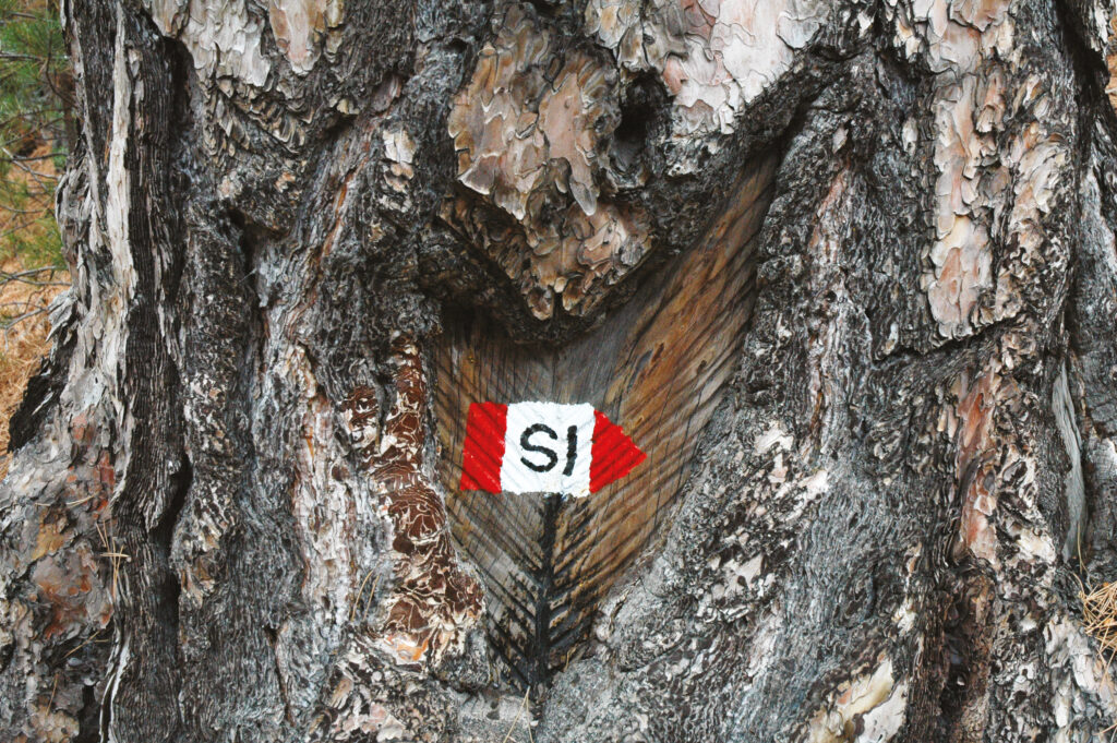
How are the Sentiero Italia CAI routes marked?
The route is identified by the classic CAI red-white-red trail marking, often accompanied by the Sentiero Italia logo. This signage indicates the direction of the route and ensures continuity along the stages.
The maintenance of the trail markers is carried out by the sections of the Italian Alpine Club and by local volunteers.
How difficult is the Sentiero Italia?
The stages of the Sentiero Italia present different levels of difficulty according to the CAI hiking classification.
They range from Tourist routes (T), which are simpler and more accessible, to itineraries for Expert Hikers (EE) that require greater technical and physical preparation.
Before starting a stage, it is always important to consult the technical description and evaluate elevation gain, distance and terrain conditions.
Where can you find the GPX tracks and technical information for the stages?
Updated information about the Sentiero Italia stages is available in the official interactive map.
Each stage includes a detailed page with:
-
technical data
-
route description
-
hospitality points (where available)
-
photographs
-
downloadable GPX tracks useful for navigation.
What is the SICAI Hiker’s Passport?
The Hiker’s Passport is the official credential of the Sentiero Italia CAI. It works as a travel diary where hikers can collect stamps from the stages they have completed.
Stamps can be obtained at mountain huts, accredited accommodation facilities and official points along the route.
In addition to certifying the journey, the passport also represents a keepsake of the experience lived along the Trail.
Where can you sleep along the Sentiero Italia?
Along the route there is a network of facilities that host hikers, including:
-
Alpine and Apennine mountain huts
-
local accommodation facilities
-
accredited SICAI hospitality points.
Many of these facilities are part of the official network and offer services dedicated to hikers, such as meals, trail information and the Hiker’s Passport stamp.
How can I contribute to the Sentiero Italia CAI project?
The Sentiero Italia lives thanks to the work of volunteers and the support of the community. It is possible to contribute in several ways:
-
by participating in the activities of the CAI sections
-
by promoting responsible and sustainable tourism along the trail.
Every contribution helps maintain and enhance this great hiking network that crosses all of Italy.